
← Digital Solutions

TERTIB / Geospatial Permit & Advertising Oversight

Every permit has a place.
Every finding has a next step.

Terbit. Petakan. Pantau. Tindak.

Bring the permit record and the actual condition of an advertising object into the same view.

TERTIB connects advertising-permit administration, the GRP geospatial map, QR identification and mobile inspections in one platform. Regional teams can follow an object from application and issuance through installation, inspection, monitoring and renewal or authorized follow-up.

Location-based records.Documented field conditions.Coordinated follow-through.

The oversight challenge

An issued permit needs a continuing connection to the field.

A permit record is more useful when teams can see where the object stands, whether its permit remains valid and what an inspection found.

When licensing records, advertising-tax information, object locations and inspection evidence sit in separate systems, teams need to reconcile them before deciding which objects need attention. Expiry dates and unresolved findings can be difficult to follow across departments.

TERTIB connects these records around the advertising object and its location. A shared map supports oversight, while QR identification and mobile reporting connect field observations with the permit history and subsequent action.

Inside TERTIB

A connected lifecycle, visible on the map.

Licensing teams, revenue agencies and field inspectors work from connected object records, with the relevant status and responsibility visible at each stage.

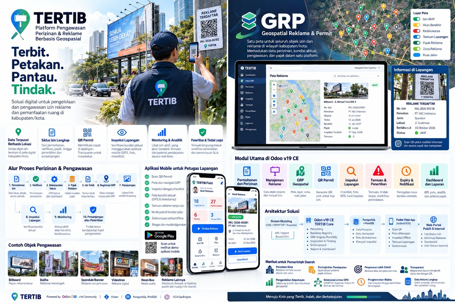
TERTIB overview showing advertising-permit administration, the GRP map, QR permit lookup, mobile inspections, the ten-stage workflow and solution architecture.
Supplied product overview. Illustrative interfaces, identifiers and sample figures explain the platform's scope. View the full-size overview ↗

01 / From application to renewal

Permit lifecycle

Connect applications, document verification, technical recommendations, advertising-tax validation and permit issuance. Keep validity dates and renewal decisions with the object they concern.

A traceable permit history, linked to its location.

02 / Geospatial Reklame & Permit

GRP

Bring advertising objects and permit records into a shared map. Layer active, expiring and expired permits with field findings, advertising-tax information, advertising zones and road corridors.

One spatial view of records, conditions and priorities.

03 / QR identification & mobile reporting

Field inspection

Identify an object through its QR Permit, navigate to its location and record checklist results, photographs, GPS position and timestamps. Offline inspection and synchronization support fieldwork with intermittent connectivity.

Recorded field conditions that can be compared with the permit.

04 / Findings, notifications & reporting

Oversight & follow-up

Move findings into assigned follow-up workflows, monitor validity dates and review case progress. Dashboards combine permit status, inspections and advertising-tax information for coordinated oversight.

Visible responsibilities from a finding through its resolution.

GRP / Geospatial Reklame & Permit

One map. Several layers of context.

GRP brings permits and advertising objects into a shared spatial workspace for the regency or city.

See permit status alongside inspection findings, advertising zones, road corridors and tax information. Open the relevant object record to review its identity, validity period and inspection history before planning the next step.

Map layers

  • Active permits
  • Expiring permits
  • Expired permits
  • Field findings
  • Advertising-tax information
  • Advertising zones
  • Road corridors

Eight connected modules

From the application desk to the street.

01

Applications & permitting

Organize object locations, designs, dimensions, application requirements, verification and issuance in a connected permit workflow.

02

Advertising registry

Maintain advertising-object records and their permit history, including the location and characteristics needed for oversight.

03

GRP geospatial map

Review map layers, advertising zones and road corridors alongside permit status and field findings.

04

QR Permit

Generate a unique QR identifier for each permit, supporting field identification and access to published permit information.

05

Field inspection

Record checklists, photographs, GPS positions and inspection results through the mobile application.

06

Findings & enforcement follow-up

Connect verified findings with an assigned handling workflow, supporting documents and progress monitoring.

07

Expiry & notifications

Track validity periods and automatic reminders so teams can examine upcoming expirations and renewal priorities.

08

Dashboards & reports

Bring KPIs, spatial analysis, permit status and advertising-tax potential into operational and management reporting.

The permit & oversight journey

Keep each stage linked to the same object.

A ten-stage workflow connects administration and field oversight. Technical reviews, tax requirements and authorized follow-up are configured around the regional organization's procedures.

  1. 01

    Permit application

    Record the proposed object's location, design, size and application requirements.

  2. 02

    Verification

    Review application documents and requirements before advancing the request.

  3. 03

    Technical recommendation

    Coordinate the relevant department's review when a technical recommendation is needed.

  4. 04

    Advertising-tax validation

    Record the validation of applicable advertising-tax requirements as part of the workflow.

  5. 05

    Permit issuance

    Record the permit number and validity dates for the approved object.

  6. 06

    GRP registration

    Place the registered object on the map with its permit record.

  7. 07

    Installation record

    Upload photographs documenting the installed advertising object.

  8. 08

    Field inspection

    Check actual conditions with a mobile checklist, photographs and location evidence.

  9. 09

    Monitoring

    Review active, expiring and expired permits alongside findings and inspection history.

  10. 10

    Renewal or follow-up

    Continue the appropriate renewal or enforcement workflow based on reviewed records and findings.

The mobile field workflow

Scan the object. Record the actual condition.

The field application connects an inspector's observations to the permit and the location being inspected.

Scan a QR Permit, open the object record and use the map for navigation. Complete an inspection checklist and capture photographs, GPS position and timestamps. Findings can enter the handling workflow for the responsible team to review.

Corridor patrol mode supports location-based fieldwork, including recording advertising objects without a permit. Offline inspection and automatic synchronization help retain observations when connectivity is interrupted.

Advertising objects covered

  • Billboards
  • Baliho / display boards
  • Banners & streamers
  • Videotron / digital displays
  • Neon box signage
  • Other locally defined advertising objects

Object categories, checklists and follow-up procedures are configured for the region's scope of oversight.

Who it supports

Shared records across regional responsibilities.

Regional governments & licensing teams

Coordinate application reviews, technical recommendations, permit issuance and renewal with location-based records.

Revenue agencies / Bapenda

Review advertising-tax records and potential alongside the permit registry and mapped objects.

Satpol PP & field inspectors

Identify objects, inspect actual conditions and document findings and authorized follow-up.

Partner departments & the public

Support coordination with relevant departments and provide public access to the permit information selected for publication.

In practice

Turn mapped information into reviewed action.

Scenario 01

Check an installed advertising object

An inspector scans its QR Permit, reviews the record and compares actual conditions with the registered object. Photos and checklist results remain connected to the inspection.

Scenario 02

Prioritize expiring permits

A licensing team reviews expiring objects on GRP, examines the permit history and coordinates the renewal workflow with the relevant departments.

Scenario 03

Follow up an unregistered object

A field officer records a finding with its location and photographs. The responsible team verifies it, assigns follow-up and monitors progress through the handling workflow.

A regional implementation

Connect the platform with your existing records and responsibilities.

TERTIB brings the permit registry, geospatial data, inspection records and reporting into a modular operational foundation.

The supplied architecture uses Odoo 19 Community Edition, PostgreSQL with PostGIS, a Flutter field application and public and internal web portals. Object records carry permit information, photographs, documents and inspection history.

API connections and Excel/CSV imports support integration with existing systems, including OSS, DPMPTSP and Bapenda. Scope the interfaces, data mapping, access permissions and departmental workflows with the respective owners before deployment.

The public portal supports permit-status lookup and advertising information. Optional open-data publication is configured around the records approved for public access.

Is TERTIB available?

TERTIB and the capabilities presented in the supplied overview are available and operational. A demonstration can cover permitting, GRP, QR identification, mobile inspections and follow-up. The deployment scope is agreed with the regional organization.

What is GRP?

GRP stands for Geospatial Reklame & Permit. It is the spatial workspace within TERTIB, bringing advertising objects, permit status, inspection findings, zones and related records into a shared map.

Can inspectors work offline?

The mobile application includes offline inspections and online/offline synchronization. Inspection data synchronizes when connectivity returns; confirm supported devices and the intended field workflow during deployment planning.

What information can the public see?

The architecture includes public and internal portals, including permit-status lookup and advertising information. Optional open-data publication is configured around the information approved for release. Internal working records remain subject to the organization's access controls.

How does TERTIB connect with existing systems?

The supplied architecture includes API and Excel/CSV import connections with existing systems, including OSS, DPMPTSP and Bapenda. Interfaces, data mapping and access arrangements are agreed with the respective system owners for each deployment.

How does TERTIB relate to PAMONG?

TERTIB focuses on advertising permits, location-based oversight and inspections. PAMONG covers broader Satpol PP command and field operations. They address related responsibilities; any connection between the products is scoped separately during implementation.

Explore TERTIB

Connect the permit.
Map the responsibility.

Request a demonstration of the permit workflow, GRP map, QR identification, mobile inspection and reporting relevant to your region.

Request a demonstration