
← Digital Solutions

PAMONG / Satpol PP Operations & Command Platform

One operating picture.
Coordinated field action.

Pantau. Respon. Tindak. Kendalikan.

Connect the command center with the people, incidents and responsibilities on the ground.

PAMONG brings Satpol PP operation planning, geospatial monitoring, mobile reporting and case management into one platform. It supports local-government teams in coordinating public-order work and documenting regional enforcement activities from the first report through follow-up.

Kota tertib.Masyarakat aman.Pemerintahan lebih efektif.

The operational challenge

A field report is only the beginning of the work.

Public-order operations depend on information moving between the field, the command center and the personnel responsible for follow-up.

When location reports, assignments, photographs and case documents are spread across separate channels, teams have to reconstruct the situation before they can coordinate a response. Leaders also need to see which incidents are verified, which teams are deployed and which cases still need attention.

PAMONG connects those stages in one operating workflow. A shared map supports coordination; structured records carry the observation, assignment, evidence and outcome into management reporting.

Inside PAMONG

Four connected modules. One shared operation.

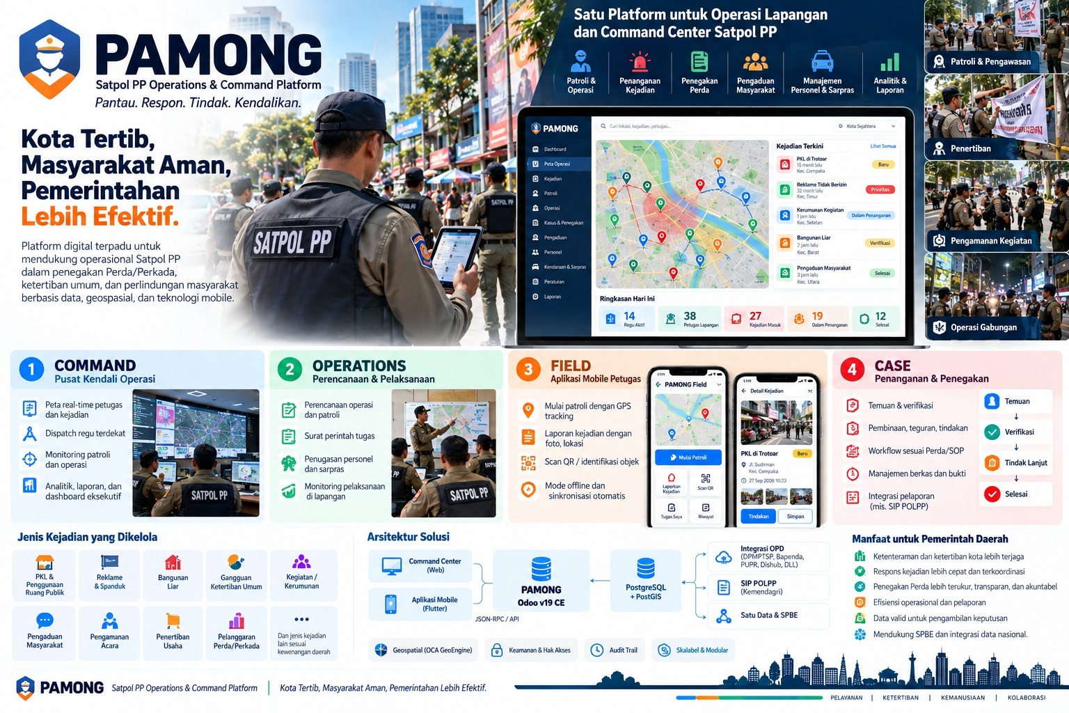
From the web command center to the mobile field application, PAMONG keeps planning, field observations and documented follow-up connected.

PAMONG product overview showing the command center map, four modules Command, Operations, Field and Case, mobile reporting and government integration architecture.
Supplied product overview. Interface illustrations, scenarios and sample figures explain the platform's scope. View the full-size overview ↗

01 / Operations command center

Command

Bring officer locations, incidents and active operations into a shared map. Dispatch the nearest suitable team, follow patrol progress and review operational reports from a central workspace.

A common operating picture for leaders and dispatchers.

02 / Planning & execution

Operations

Plan operations and patrols, prepare duty orders, assign personnel and equipment, and monitor execution in the field. Keep the planned work connected to the team carrying it out.

Clear assignments and coordinated deployment.

03 / Mobile officer application

Field

Start GPS-tracked patrols, report incidents with photos and location, identify objects through QR scanning and access assigned work. Offline capture and automatic synchronization support work when connectivity changes.

Field observations that become usable operational records.

04 / Follow-up & regional enforcement

Case

Connect findings, verification, guidance, warnings and authorized follow-up through workflows aligned with local procedures. Keep case files and supporting evidence together through closure.

A documented path from a finding to its resolution.

Core capabilities

See the situation. Assign the work. Follow it through.

01

Geospatial awareness & dispatch

See incidents and field teams on an operational map, locate nearby resources and coordinate a response with visibility of ongoing patrols and operations.

02

Patrols & planned operations

Connect operation plans, duty orders, personnel assignments and equipment with progress monitoring. Support routine patrols, event security and joint operations.

03

Incident & complaint handling

Organize field findings and community complaints with location, photographs, verification and handling status, so information can move into an assigned follow-up workflow.

04

Case files & documented action

Keep guidance, warnings, follow-up actions, evidence and supporting documents connected to the case. Use the workflow to record decisions taken by authorized personnel.

05

Personnel, vehicles & equipment

Bring team and resource administration into the operational workspace, supporting assignment of personnel, vehicles and infrastructure to the work that needs them.

06

Analytics & management reporting

Review incident volumes, active deployments, cases in progress and completed work. Operational summaries and executive dashboards help leaders examine activity and follow-through.

A documented case journey

Keep the finding connected to the outcome.

The case workflow makes each stage visible to the team responsible for it. Verification and authorized follow-up remain part of the operational process.

  1. 01

    Finding

    An officer records a field observation or the team receives a community complaint.

  2. 02

    Verification

    The responsible team checks the information, location, context and supporting material.

  3. 03

    Follow-up

    Authorized personnel coordinate the appropriate guidance, warning or action and record the outcome.

  4. 04

    Closure

    The case's status and supporting documents are brought together for reporting and review.

Types of work the platform can organize

  • Street vendors & public-space use
  • Billboards & banners
  • Unauthorized buildings
  • Public-order disturbances
  • Events & crowds
  • Community complaints
  • Event security
  • Business-order enforcement
  • Regional regulation violations

Incident categories and workflows are configured around the regional team's responsibilities, regulations and operating procedures.

Who it supports

Different roles. A connected responsibility.

Regional governments & Satpol PP leadership

Review the operating picture, deployment priorities, case progress and management reporting.

Command-center operators & dispatchers

Connect incoming information with nearby teams, current operations and a coordinated response.

Patrol teams & field officers

Receive assignments and record location-based observations, photos and follow-up through the mobile application.

Case administrators & partner departments

Organize verified findings, case documentation and coordination with the relevant government departments.

In practice

Coordinate the daily work and the moments that need a response.

Scenario 01

A routine patrol finds an issue

An officer records a finding with photographs and location. The command team reviews it, assigns follow-up and keeps the resulting documentation with the case.

Scenario 02

A public event needs coordination

Operations staff prepare duty orders and assign personnel and equipment. The command center monitors deployment while field teams report conditions and incidents through the mobile application.

Scenario 03

A complaint needs follow-through

A community complaint enters the handling workflow. The responsible team verifies the information, documents its response and updates the case status for reporting.

Fit within regional government

Connect the operation with the wider government ecosystem.

PAMONG combines web command-center access, a mobile officer application and geospatial records with a modular operational foundation.

The supplied architecture presents Odoo 19 Community Edition, a Flutter mobile application, PostgreSQL with PostGIS, and API connections. Access controls and an audit trail support the organization of operational responsibilities and recorded activity.

Integration targets include relevant regional departments, SIP POLPP, and Satu Data and SPBE. Discuss the interfaces, data-sharing scope and local reporting requirements with each system owner when planning a deployment.

Is PAMONG available?

PAMONG is available and operational. A demonstration can cover the command center, operation planning, mobile field application and case-management workflow. Discuss the configuration and deployment scope needed by your organization.

Can officers work with intermittent connectivity?

The Field module includes offline mode and automatic synchronization. Data synchronization depends on connectivity returning; the team should confirm supported devices and offline workflows during deployment planning.

Does the platform replace an officer's judgment?

PAMONG organizes information, assignments, case workflows and evidence. Verification, authorization and enforcement decisions remain with the responsible personnel under the applicable local procedures.

How do government integrations fit the deployment?

The product architecture includes API integration with regional departments, SIP POLPP, and the Satu Data and SPBE ecosystem. Each deployment should agree the target systems, access arrangements, data mapping and interfaces with their respective owners.

Explore PAMONG

Bring command and field
into the same picture.

Request a demonstration of the operational map, mobile workflow, case management and reporting relevant to your regional team.

Request a demonstration